

Phase 1: Charting the Course
Any planning process must begin with a comprehensive understanding of the site's existing conditions. Below you'll find a summary of our explorations of the Santa Monica Airport site, including its present and historical conditions. If you're interested in learning more, head over to the Learn & Engage page to view the Virtual Education Session 1 video.
New Content
New Content
Phase 3A Survey closes 11:59pm, Sunday, April 27, 2025
Phase 1: Charting the Course
Any planning process must begin with a comprehensive understanding of the site's existing conditions. Below you'll find a summary of our explorations of the Santa Monica Airport site, including its present and historical conditions. If you're interested in learning more, head over to the Learn & Engage page to view the Virtual Education Session 1 video.
New Content
Urban Centers
The site's proximity to the urban centers of Santa Monica and the larger Los Angeles region presents an exceptional opportunity for it to emerge as a well-connected community resource.
Ecology Connector
The site's location and topography play an important role in shaping Santa Monica's future ecological health, enabling better connectivity with the larger regional ecology.
The Opportunity
The Santa Monica Airport is strategically positioned to be reborn as a central community resource, with park and recreation offerings that feature captivating views of the mountains, ocean, and downtown Los Angeles.
Population Density
The airport site sits within the dense urban fabric of Santa Monica and Los Angeles's westside residential neighborhoods.
0-9,999
10,000-19,999
20,000-29,999
>30,000
People per sq. mile
Site Accessibility
Most Santa Monica residents can access the site via a 20-minute bike ride.
10 min walk
15 min walk
20 min walk
10 min bike
20 min bike
Site Hydrology
The Santa Monica Airport has a relatively low flood risk compared to other surrounding areas to the east.
Flow to Santa Monica Bay
Flow to Ballona Creek
Flood Risk
low-high
On-site Today
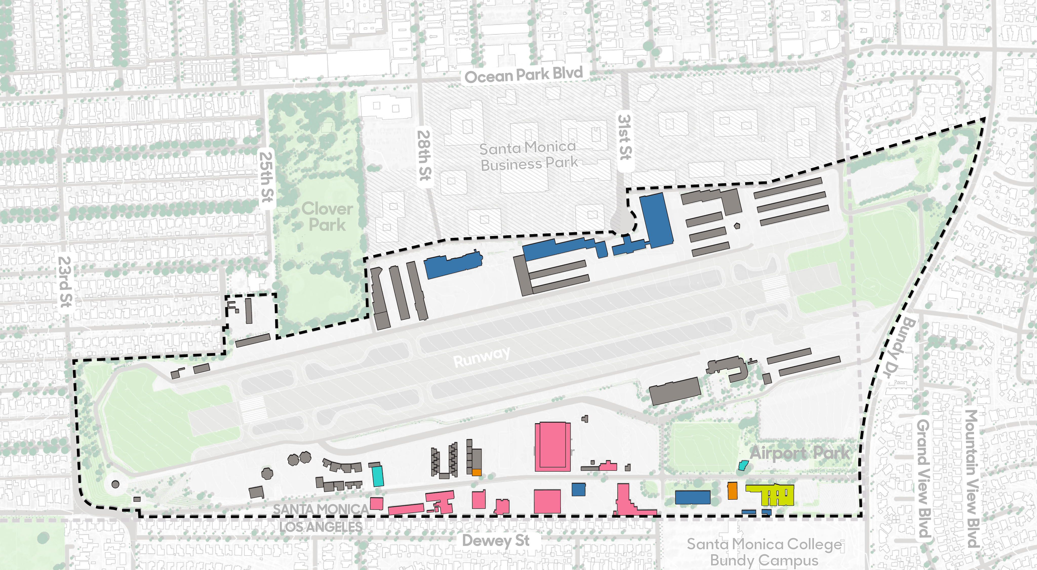
A variety of different uses and building types occupy the site today. In addition to aviation uses, the site is home to retail, art, cultural, institutional, and office facilities.
Retail / Restaurant
Arts/Culture/Institutional
Aviation Use
Office
Scheduled to be Demolished
Other
Site Materials
The Santa Monica Airport is 80% covered by impervious surfaces which include buildings, concrete, runway, plazas, and paths.
Pervious Surface
20%
Lawn
Sports Field
Interim landscape
Semi-Pervious Surface
80%
Building
Concrete & Asphalt
Tarmac
Plaza & Pathways
Site Topography
With the exception of the steep bluff drop off on the west side, the site is characterized by a relatively gentle east to west slope, which enables a clear view of the bay from many points of the property.
0-3 degrees
3-5
5-8
8-15
15-33
>33
Urban Centers
The site's proximity to the urban centers of Santa Monica and the larger Los Angeles region presents an exceptional opportunity for it to emerge as a well-connected community resource.
Ecology Connector
The site's location and topography play an important role in shaping Santa Monica's future ecological health, enabling better connectivity with the larger regional ecology.
The Opportunity
The Santa Monica Airport is strategically positioned to be reborn as a central community resource, with park and recreation offerings that feature captivating views of the mountains, ocean, and downtown Los Angeles.
Population Density
The airport site sits within the dense urban fabric of Santa Monica and Los Angeles's westside residential neighborhoods.
0-9,999
10,000-19,999
20,000-29,999
>30,000
People per sq. mile
Site Accessibility
Most Santa Monica residents can access the site via a 20-minute bike ride.
10 min walk
15 min walk
20 min walk
10 min bike
20 min bike
Site Hydrology
The Santa Monica Airport has a relatively low flood risk compared to other surrounding areas to the east.
Flow to Santa Monica Bay
Flow to Ballona Creek
Flood Risk
low-high
On-site Today
A variety of different uses and building types occupy the site today. In addition to aviation uses, the site is home to retail, art, cultural, institutional, and office facilities.
Retail / Restaurant
Arts/Culture/Institutional
Aviation Use
Office
Scheduled to be Demolished
Other
Site Materials
The Santa Monica Airport is 80% covered by impervious surfaces which include buildings, concrete, runway, plazas, and paths.
Pervious Surface
20%
Lawn
Sports Field
Interim landscape
Semi-Pervious Surface
80%
Building
Concrete & Asphalt
Tarmac
Plaza & Pathways
Site Topography
With the exception of the steep bluff drop off on the west side, the site is characterized by a relatively gentle east to west slope, which enables a clear view of the bay from many points of the property.
0-3 degrees
3-5
5-8
8-15
15-33
>33


EXISTING CONDITIONS
Project Site
Project Site
EXISTING CONDITIONS
Project Site

Urban Centers
The site's proximity to the urban centers of Santa Monica and the larger Los Angeles region presents an exceptional opportunity for it to emerge as a well-connected community resource.
Ecology Connector
The site's location and topography play an important role in shaping Santa Monica's future ecological health, enabling better connectivity with the larger regional ecology.
The Opportunity
The Santa Monica Airport is strategically positioned to be reborn as a central community resource, with park and recreation offerings that feature captivating views of the mountains, ocean, and downtown Los Angeles.
Population Density
The airport site sits within the dense urban fabric of Santa Monica and Los Angeles's westside residential neighborhoods.
0-9,999
10,000-19,999
20,000-29,999
>30,000
People per sq. mile
Site Accessibility
Most Santa Monica residents can access the site via a 20-minute bike ride.
10 min walk
15 min walk
20 min walk
10 min bike
20 min bike
Site Hydrology
The Santa Monica Airport has a relatively low flood risk compared to other surrounding areas to the east.
Flow to Santa Monica Bay
Flow to Ballona Creek
Flood Risk
low-high
On-site Today
A variety of different uses and building types occupy the site today. In addition to aviation uses, the site is home to retail, art, cultural, institutional, and office facilities.
Retail / Restaurant
Arts/Culture/Institutional
Aviation Use
Office
Scheduled to be Demolished
Other
Site Materials
The Santa Monica Airport is 80% covered by impervious surfaces which include buildings, concrete, runway, plazas, and paths.
Pervious Surface
20%
Lawn
Sports Field
Interim landscape
Semi-Pervious Surface
80%
Building
Concrete & Asphalt
Tarmac
Plaza & Pathways
Site Topography
With the exception of the steep bluff drop off on the west side, the site is characterized by a relatively gentle east to west slope, which enables a clear view of the bay from many points of the property.
0-3 degrees
3-5
5-8
8-15
15-33
>33
EXISTING CONDITIONS
City
EXISTING CONDITIONS
City
Urban Centers
The site's proximity to the urban centers of Santa Monica and the larger Los Angeles region presents an exceptional opportunity for it to emerge as a well-connected community resource.
Ecology Connector
The site's location and topography play an important role in shaping Santa Monica's future ecological health, enabling better connectivity with the larger regional ecology.
The Opportunity
The Santa Monica Airport is strategically positioned to be reborn as a central community resource, with park and recreation offerings that feature captivating views of the mountains, ocean, and downtown Los Angeles.
Population Density
The airport site sits within the dense urban fabric of Santa Monica and Los Angeles's westside residential neighborhoods.
0-9,999
10,000-19,999
20,000-29,999
>30,000
People per sq. mile
Site Accessibility
Most Santa Monica residents can access the site via a 20-minute bike ride.
10 min walk
15 min walk
20 min walk
10 min bike
20 min bike
Site Hydrology
The Santa Monica Airport has a relatively low flood risk compared to other surrounding areas to the east.
Flow to Santa Monica Bay
Flow to Ballona Creek
Flood Risk
low-high
On-site Today
A variety of different uses and building types occupy the site today. In addition to aviation uses, the site is home to retail, art, cultural, institutional, and office facilities.
Retail / Restaurant
Arts/Culture/Institutional
Aviation Use
Office
Scheduled to be Demolished
Other
Site Materials
The Santa Monica Airport is 80% covered by impervious surfaces which include buildings, concrete, runway, plazas, and paths.
Pervious Surface
20%
Lawn
Sports Field
Interim landscape
Semi-Pervious Surface
80%
Building
Concrete & Asphalt
Tarmac
Plaza & Pathways
Site Topography
With the exception of the steep bluff drop off on the west side, the site is characterized by a relatively gentle east to west slope, which enables a clear view of the bay from many points of the property.
0-3 degrees
3-5
5-8
8-15
15-33
>33
EXISTING CONDITIONS
Region

Let's shape the future of Santa Monica Airport site together.
Phase 3A Survey closes Sunday, April 27, 2025
New Content
Let's shape the future of Santa Monica Airport site together.
Phase 3A Survey closes Sunday, April 27, 2025
New Content
Let's shape the future of Santa Monica Airport site together.
Phase 3A Survey closes Sunday, April 27, 2025
New Content
Let's shape the future of Santa Monica Airport site together.
Phase 3A Survey closes Sunday, April 27, 2025
New Content